- by foxnews
- 23 Jun 2026
Smart street sensors could be watching your city next
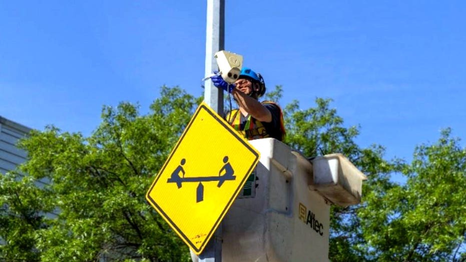
New York City is expanding AI-powered street sensors to 100 locations, using computer vision to count pedestrians, cyclists and vehicles for safer roads.
- by foxnews
- 23 Jun 2026
- in technology
Across America, towns and cities are trying to solve the same problems. Drivers speed through busy corridors. Pedestrians cross where there is no crosswalk. Cyclists squeeze past parked cars. Buses get stuck in traffic. City leaders often have to make expensive safety decisions with limited data. Now, sensors can watch those patterns all day and all night.
Sign up for my FREE CyberGuy Report
The New York City Department of Transportation says it will expand its street activity sensor program to about 100 locations across the five boroughs. The city first tested the sensors at 20 intersections during a pilot program that began in 2023. Now, it plans to add about 80 more locations.
The devices are mounted on city street infrastructure, such as poles or signs. Beyond counting different road users, the sensors can also measure speeds, capture turning movements and map how people move through a street or intersection.
Traditional traffic studies often depend on workers standing near a road and counting what they see. That can work, but it has limits.
Street safety often starts after something terrible happens. A crash occurs. A complaint gets filed. A dangerous intersection gets attention.
Think about a car door that swings open near a cyclist. Or a driver who turns while a pedestrian is already crossing. Or a delivery truck that blocks a driver's view at a busy corner. Nobody may get hurt in that moment. Still, the pattern can reveal real danger.
If sensors detect repeated close calls in the same place, city planners may have a stronger reason to act before a crash happens. That could mean adding a crosswalk, changing signal timing, redesigning a bike lane or adjusting how curb space gets used.
The most interesting part of this technology may be what it shows cities about everyday habits. Roads rarely work the way they look on a planning map. People cross where it feels convenient. Cyclists avoid lanes that feel unsafe. Drivers speed up when a road feels too wide. Buses slow down when curb space gets clogged. A sensor can help document those patterns.
That could help cities answer practical questions: Are pedestrians crossing in the same unsafe spot every day? Do cyclists avoid a certain bike lane because cars block it? Do buses slow down near busy loading zones? Are drivers turning too quickly near a school? Is a street redesign actually working? Better answers could lead to better decisions. But only if cities use the data in a way people can see and understand.
This is where many people will pause. A sensor on a street pole can sound helpful. It can also sound creepy.
New York City says the sensors are designed with privacy in mind. According to the DOT, video is processed in real time and then discarded. The city says only anonymous data is kept. Faces and license plates are deliberately obscured.
That means the system is supposed to keep the traffic pattern, not the personal identity behind it.
If taxpayers help fund street sensors, the public should know what the sensors find. New York City says some information will be added to its open data page. Street safety advocates want more regular reporting. That is important.
A city should not collect information from public streets and then bury the results in a hard-to-find system. Residents should be able to see whether the technology leads to safer crossings, better bike routes, faster buses or fewer dangerous close calls.
Public reporting also helps build trust. If a city says sensors protect privacy, it should show how. If officials say sensors improve safety, they should show the results. Without that transparency, even a useful technology can feel like another layer of surveillance.
Even if you do not live in New York, this rollout is worth watching. Your city may be paying attention to how New York uses this technology. If the program helps planners make safer decisions faster, similar sensors could show up near schools, busy intersections, bike corridors or downtown streets in other communities.
If you walk often, the data could support better crosswalks and safer signal timing. Cyclists may benefit from stronger evidence for protected bike lanes. Drivers could notice new street designs that slow traffic, change turns or shift parking. Bus riders may see improvements if cities use the data to find where transit gets delayed.
However, cities need clear policies before these systems spread. They should explain what the sensors collect, what they delete, who reviews the data and how the public can see the results. Safer streets are a good goal. Public trust is part of getting there.
Take my quiz: How safe is your online security?
Think your devices and data are truly protected? Take this quick quiz to see where your digital habits stand. From passwords to Wi-Fi settings, you'll get a personalized breakdown of what you're doing right and what needs improvement. Take my Quiz here: Cyberguy.com
Would smart street sensors make you feel safer, or make public streets feel a little too watched? Let us know by writing to us at Cyberguy.com
Sign up for my FREE CyberGuy Report
Copyright 2026 CyberGuy.com. All rights reserved.
you may also like

- by foxnews
- 23 Jun 2026
FBI says Russian hackers hijacked old Wi-Fi routers
- by foxnews
- 23 Jun 2026
UK to ban TikTok, YouTube, other social media apps for children under 16, Starmer says


travel
- by foxnews
- descember 09, 2016
Cruise tipping charges are 'out of control,' say passengers as companies tout 'exceptional service'
Cruise lines including Holland America, MSC Cruises and Carnival raise daily gratuity charges in 2026, frustrating passengers on hidden costs. The cruise lines cite their great service.
read more